Nate Local Watch/Warning Statement/Advisory Number 14
National Weather Service Peachtree City GA  AL162017
521 PM EDT Sat Oct 7 2017

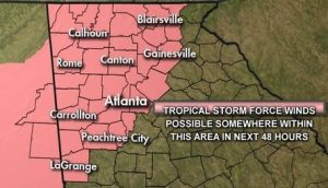
...TROPICAL STORM WARNING IN EFFECT...

A Tropical Storm Warning means Tropical storm wind conditions are
expected somewhere within this area and within the next 36 hours

* LOCATIONS AFFECTED
    - Lafayette

* WIND
    - LATEST LOCAL FORECAST: Tropical storm force winds remain
      possible
        - Peak Wind Forecast: 20-30 mph with gusts to 45 mph

    - CURRENT THREAT TO LIFE AND PROPERTY: Elevated
        - The wind threat has remained nearly steady from the
          previous assessment.

    - POTENTIAL IMPACTS: Limited

* FLOODING RAIN
    - LATEST LOCAL FORECAST: Flash Flood Watch is in effect
        - Peak Rainfall Amounts: Additional 4-8 inches, with locally
          higher amounts

    - CURRENT THREAT TO LIFE AND PROPERTY: Moderate
        - The flooding rain threat has remained nearly steady from
          the previous assessment.

    - POTENTIAL IMPACTS: Significant

* TORNADO
    - LATEST LOCAL FORECAST:
        - Situation is somewhat favorable for tornadoes

    - CURRENT THREAT TO LIFE AND PROPERTY: Elevated
        - The tornado threat has remained nearly steady from the
          previous assessment.

    - POTENTIAL IMPACTS: Limited

* FOR MORE INFORMATION:
    - Family emergency plans: Federal Emergency Management Agency
        - http://ready.gov/hurricanes
    - Local weather conditions and forecasts:
        - http://weather.gov/atlanta

$$
Hazardous Weather Outlook
Hazardous Weather Outlook
National Weather Service Peachtree City GA
535 PM EDT Sat Oct 7 2017

GAZ001>009-011>016-019>025-027-030>039-041>062-066>076-078>086-
089>098-102>113-082145-
Baldwin-Banks-Barrow-Bartow-Bibb-Bleckley-Butts-Carroll-Catoosa-
Chattahoochee-Chattooga-Cherokee-Clarke-Clayton-Cobb-Coweta-
Crawford-Crisp-Dade-Dawson-DeKalb-Dodge-Dooly-Douglas-Emanuel-
Fannin-Fayette-Floyd-Forsyth-Gilmer-Glascock-Gordon-Greene-
Gwinnett-Hall-Hancock-Haralson-Harris-Heard-Henry-Houston-Jackson-
Jasper-Jefferson-Johnson-Jones-Lamar-Laurens-Lumpkin-Macon-
Madison-Marion-Meriwether-Monroe-Montgomery-Morgan-Murray-
Muscogee-Newton-North Fulton-Oconee-Oglethorpe-Paulding-Peach-
Pickens-Pike-Polk-Pulaski-Putnam-Rockdale-Schley-South Fulton-
Spalding-Stewart-Sumter-Talbot-Taliaferro-Taylor-Telfair-Toombs-
Towns-Treutlen-Troup-Twiggs-Union-Upson-Walker-Walton-Warren-
Washington-Webster-Wheeler-White-Whitfield-Wilcox-Wilkes-
Wilkinson-
535 PM EDT Sat Oct 7 2017

This Hazardous Weather Outlook is for portions of North and Central Georgia.

.DAY ONE...Tonight...

...Tropical Storm Watches and Warnings In Effect For Portions Of
Northwest Georgia through Sunday Evening...

The chance for a few showers and thunderstorms will increase late
afternoon into this evening from the south as Nate approaches the
northern Gulf coast. Some storms could be strong with gusty winds
and locally heavy rainfall as the main threats.

.DAYS TWO THROUGH SEVEN...Sunday through Friday...

Periods of showers and thunderstorms will increase Sunday in
association with Tropical system Nate. Some storms could be strong
to severe with brief, spin-up tornadoes, damaging winds, and locally
heavy rainfall. Please see the latest Hurricane Local Statement for
further details. In addition, a Flash Flood Watch is in effect for
portions of north Georgia, Sunday afternoon into Monday morning,
with 3 to 5 inches of rain expected.

Despite Nate exiting the area by Monday, there will be continued
shower and storm chances through midweek. At this time, no severe
weather is expected Tuesday through Friday.

.SPOTTER INFORMATION STATEMENT...

Spotter activation will not be needed through tonight, though may
be needed Sunday.

$$
Hurricane Local Statement
Hurricane Nate Local Statement Advisory Number 14
GAZ001>009-011>016-019>025-027-030>039-041>062-066>076-078>086-089>098-102>113-080530-

Hurricane Nate Local Statement Advisory Number 14
National Weather Service Peachtree City GA  AL162017
528 PM EDT Sat Oct 7 2017

This product covers NORTH AND CENTRAL GEORGIA

**Tropical Storm Warning Now In Effect For Portions of Northwest
 Georgia**

NEW INFORMATION
---------------

* CHANGES TO WATCHES AND WARNINGS:
    - The Tropical Storm Watch has been cancelled for Clayton,
      Coweta, Dawson, DeKalb, Fayette, Forsyth, Gwinnett, Hall,
      Lumpkin, North Fulton, South Fulton, Towns, Union, and White
    - The Tropical Storm Watch has been upgraded to a Tropical Storm
      Warning for Catoosa, Chattooga, Dade, Floyd, and Walker

* CURRENT WATCHES AND WARNINGS:
    - A Tropical Storm Watch is in effect for Bartow, Carroll,
      Cherokee, Cobb, Douglas, Fannin, Gilmer, Gordon, Haralson,
      Heard, Murray, Paulding, Pickens, Polk, Troup, and Whitfield
    - A Tropical Storm Warning is in effect for Catoosa, Chattooga,
      Dade, Floyd, and Walker

* STORM INFORMATION:
    - About 460 miles southwest of Atlanta GA or about 470 miles
      south-southwest of Rome GA
    - 28.4N 89.1W
    - Storm Intensity 90 mph
    - Movement North-northwest or 345 degrees at 23 mph

SITUATION OVERVIEW
------------------

Hurricane Nate continues to progress north northwest over the Gulf of
Mexico and is expected to make landfall along the northern Gulf coast
overnight tonight. Weakening is expected after landfall, and the storm
is expected to track across Alabama and northern Georgia as a Tropical
Storm through Sunday and Sunday night. It should be noted that impacts
from heavy rain and potential tornadoes will precede the most
significant winds with this system and are possible as early as
tonight.

During the height of the storm, winds of 30 to 40 mph will be possible
with gusts as high as 50 mph across far northwest Georgia. Storm total
rainfall is expected to be on the order of 3 to 5 inches north of a
line from Rome, to Dawsonville, to Homer with locally higher amounts
possible.

POTENTIAL IMPACTS
-----------------

* WIND:
Protect against hazardous wind having limited impacts across portions
of northwest Georgia. Potential impacts in this area include:
    - Damage to porches, awnings, carports, sheds, and unanchored
      mobile homes. Unsecured lightweight objects blown about.
    - Many large tree limbs broken off. A few trees snapped or
      uprooted, but with greater numbers in places where trees are
      shallow rooted. Some fences and roadway signs blown over.
    - A few roads impassable from debris, particularly within urban
      or heavily wooded places. Hazardous driving conditions on
      bridges and other elevated roadways.
    - Scattered power and communications outages.

Elsewhere across NORTH AND CENTRAL GEORGIA, little to no impact is
anticipated.

* TORNADOES:
Protect against a tornado event having possible limited impacts
across NORTH AND CENTRAL GEORGIA. Potential impacts include:
    - The occurrence of isolated tornadoes can hinder the execution
      of emergency plans during tropical events.
    - A few places may experience tornado damage, along with power
      and communications disruptions.
    - Locations could realize roofs peeled off buildings, chimneys
      toppled, mobile homes pushed off foundations or overturned,
      large tree tops and branches snapped off, shallow-rooted trees
      knocked over, moving vehicles blown off roads, and small boats
      pulled from moorings.

* FLOODING RAIN:
Protect against dangerous rainfall flooding having possible significant
impacts across portions of North Georgia. Potential impacts include:
    - Moderate rainfall flooding may prompt several evacuations and
      rescues.
    - Rivers and tributaries may quickly become swollen with swifter
      currents and overspill their banks in a few places, especially
      in usually vulnerable spots. Small streams, creeks, and ditches
      overflow.
    - Flood waters can enter some structures or weaken foundations.
      Several places may experience expanded areas of rapid inundation
      at underpasses, low-lying spots, and poor drainage areas. Some
      streets and parking lots take on moving water as storm drains and
      retention ponds overflow. Driving conditions become hazardous.
      Some road and bridge closures.

PRECAUTIONARY/PREPAREDNESS ACTIONS
----------------------------------

* ADDITIONAL SOURCES OF INFORMATION:
- For information on creating an emergency plan see ready.ga.gov
- For information on appropriate preparations see ready.gov
- For additional disaster preparedness information see redcross.org





Comments