









 Special Weather Statement
National Weather Service Peachtree City GA
418 AM EST Sat Jan 16 2021
GAZ001>009-011>016-161915-
Dade-Walker-Catoosa-Whitfield-Murray-Fannin-Gilmer-Union-Towns-
Chattooga-Gordon-Pickens-Dawson-Lumpkin-White-
418 AM EST Sat Jan 16 2021
...LIGHT SNOW EXPECTED THROUGH EARLY THIS AFTERNOON OVER FAR
NORTH GEORGIA...
Special Weather Statement
National Weather Service Peachtree City GA
418 AM EST Sat Jan 16 2021

GAZ001>009-011>016-161915-
Dade-Walker-Catoosa-Whitfield-Murray-Fannin-Gilmer-Union-Towns-
Chattooga-Gordon-Pickens-Dawson-Lumpkin-White-
418 AM EST Sat Jan 16 2021

...LIGHT SNOW EXPECTED THROUGH EARLY THIS AFTERNOON OVER FAR
NORTH GEORGIA...
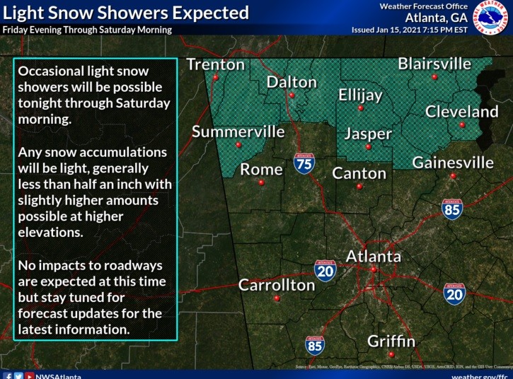
A band of light precipitation is expected to move into far northwest Georgia this morning behind a cold front, and spread into far northeast Georgia during the day. The area generally north of Rome to Dawsonville will be the most favorable area for snow. Based on the relatively cold and dry conditions in place, the precipitation is expected to fall mostly as light snow or a rain and snow mix. Precipitation should diminish across the area by early afternoon. Any snow accumulations will be light, generally less than half an inch with slightly higher amounts possible at higher elevations. No impacts to roadways are expected at this time, but residents should monitor the latest forecast and be prepared in case the forecast changes.
Comments