







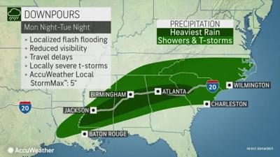
There a potential for Chattooga County to get several inches of rain over the next few days as a stormfront is likely to produce wet weather over much of the southern United States.
The National Weather Service has posted a hazardous weather outlook beginning Monday night and lasting through Thursday. The main path of the any potentially severe weather appears to be going south of Floyd County, primarily along the I-20 corridor.
The wet weather stems from some of the same storms that dumped massive amounts of snowfall in the Colorado and Wyoming this past weekend.
On Tuesday and Tuesday night we can expect warm weather, with a high around 65, and rain showers and thunderstorms carrying over from Monday. New rainfall amounts from Monday and Tuesday are expected to fall within the inch to inch and a half range.
Wednesday we can expect a high of around 71 and a low in the upper 50s as well as showers and thunderstorms with periods of heavy rainfall with the potential of an inch to an inch of a half of rain.
Continuing into Thursday, much of the same but the rainfall should begin to dwindle through the day. Thursday’s high is expected to reach around 71 with a low of 45.
The weather is expected to clear up on Friday with the chance of rain remaining low throughout the weekend.
Comments