


Carlton Ervin Johnson, 47, of 100 Summerville Gardens in Summerville, was arrested at 1:30 p.m. Wednesday by the Rome Police Department and was charged with probation violation. He remained in jail Thursday morning.
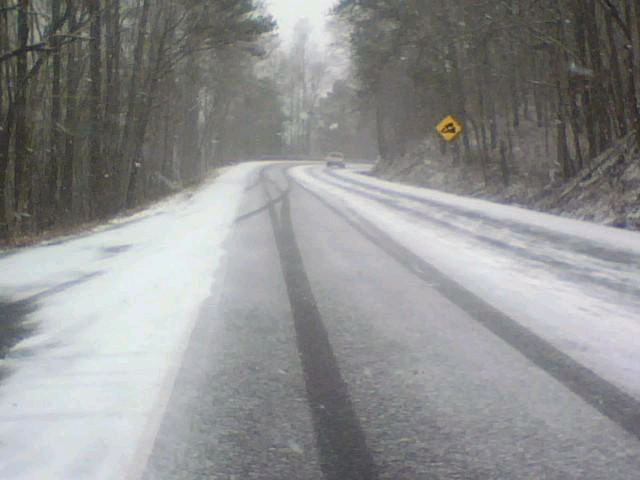
Chattooga County is waking up this morning to some slippery roads and the potential for another round of vehicle wrecks.
Dispatchers at the E9-1-1 Center and deputies say the roads are icy.
Although one Chattooga County truck ran all night spreading salt on rural roads, Commissioner Jason Winters said it is impossible to keep all 560-miles of county roads salted. He urges people to stay tuned to news reports about dangerous roads.
Roads that are currently closed are: Spring Creek Road, Farmersville Road and Little Sand Mountain Roads. Other roads may be added to this list as icy conditions continue
This list of closed roads does not mean ice hasn’t formed on other county and state routes. These are just the ones that are extremely dangerous to use for travel.
Yesterday evening the sheriff’s department and other local emergency responders were kept busy answering a parade of wreck calls. As people start venturing out this morning, Commissioner Winters fears another string of accidents could begin.
The Summerville News
This week, Lamar Perry began his new position as Scout executive of the Northwest Georgia Council for the Boy Scouts of America.
Perry, a graduate of the University of Georgia and former walk-on wide receiver for the Bulldogs, has spent more than 12 years in Scouting, working for regional councils in Tennessee, Georgia and South Carolina.
“This is an area I’ve always wanted to get back to,” he said.
The Nashville, Tenn., native said that he doesn’t have a firm vision for the future of the Northwest Georgia Council, but one thing he’s hoping to do is promote Scouting with minorities.
RNT
Chattooga County Public Works Director Lamar Canada told AM 1180 Chattooga County Radio this morning that a tractor trailer driver spent the night in the cab of his truck on Little Sand Mountain after his rig jacknifed last night.
Canada said that the driver had a sleeper on his truck and rather than try to get wreckers and salt trucks up the mountain, Canada closed the road. It remains closed this morning. The driver was not injured.
SHORT TERM FORECAST
NATIONAL WEATHER SERVICE PEACHTREE CITY GA
634 PM EST THU JAN 7 2010
GAZ001>009-011>016-019>025-027-030>039-041>062-066>076-078>084-
089>096-102>105-107-080100-
634 PM EST THU JAN 7 2010
.NOW…
A MIXTURE OF RAIN…SLEET…SNOW AND FREEZING RAIN WILL CONTINUE
ACROSS PORTIONS OF NORTH AND CENTRAL GEORGIA THROUGH THE EVENING. AT
630 PM EST…A MIXTURE OF LIGHT SNOW…SLEET AND FREEZING RAIN WAS
REPORTED GENERALLY ALONG AND NORTH OF A LINE FROM FRANKLIN TO
PEACHTREE CITY TO ATHENS. SOUTH OF THIS LINE THE PRECIPITATION WAS
PRIMARILY IN THE FORM OF RAIN. SLEET OR SNOW MAY BEGIN TO MIX WITH
THE RAIN ACROSS CENTRAL GEORGIA LATER THIS EVENING AS TEMPERATURES
CONTINUE TO DROP. ACCUMULATIONS OF SNOW WILL GENERALLY BE AN INCH OR
LESS ACROSS NORTH GEORGIA…WITH MANY PLACES ONLY RECEIVING A
DUSTING. LOCALLY HIGHER ACCUMULATIONS ARE POSSIBLE AT HIGHER
ELEVATIONS. TEMPERATURES HAVE DROPPED TO AT OR BELOW FREEZING ALONG
AND NORTH OF A LINE FROM BREMEN TO ALPHARETTA TO GAINESVILLE. NORTH
OF THIS LINE THERE MAY BE ICY PATCHES ON THE ROADWAYS…ESPECIALLY
ON BRIDGES AND OVERPASSES. MOTORISTS ARE URGED TO SLOW DOWN AND USE
CAUTION.
Chattooga County Public Works Director Lamar Canada told AM 1180 that Highway 27 going over Taylors Ridge is now open. Motorist should still use extreme caution when traveling over the ridge and on other area roads this evening.
EMA Director Eddie Henderson told AM 1180 that one lane each was is open on Taylor’s Ridge. The inside lane is closed. Use caution if you must travel Highway 27 going over Taylor’s Ridge.
All roads are open & passable with a few slick spots reported. Use caution if headed out on the roads though. County work crews are spreading salt on icy spots on both Lookout Mountain at Cloudland and Little Sand Mountain. Use extra caution in these areas and on bridges (they ice over before roadways do).
Make sure you have a charged cell phone, flash light, blanket and plenty of fuel in your vehicle if you do venture out – just in case of an emergency. Make sure your pets are taken care of too. Fresh water and shelter should be ensured. More updates will follow here and you can also get up to the minute information by visiting www.chattoogainfo.com and www.thesummervillenews.com.
Chattooga County Public Works director Lamar Canada told AM 1180 that the county’s road crews are out in force throughout the county working on the slick road conditions.
Canada said that the county has plenty of salt to deal with the icy conditions and the trucks are working to get to all of the trouble spots this afternoon and evening. Trucks have been out since this morning in several areas including:
Highway 48 at Cloudland
Stateline Road and Highway 157 in Cloudland
Haywood Valley Road
Trion – Teloga Road
Penn Bridge Road
Gore – Subligna Road
Little Sand Mountain
East Armuchee Road
Motorist are urged to use extreme caution when travelling the roadways this afternoon and are urged to stay at home this evening if at all possible.
URGENT – WINTER WEATHER MESSAGE
NATIONAL WEATHER SERVICE PEACHTREE CITY GA
403 PM EST THU JAN 7 2010
…LIGHT ACCUMULATIONS OF SNOWFALL ARE STILL EXPECTED ACROSS NORTH
AND PARTS OF CENTRAL GEORGIA THROUGH THIS EVENING…
.A FAST MOVING COLD FRONT WILL APPROACH NORTH AND CENTRAL GEORGIA
THIS EVENING…SPREADING ANOTHER ROUND OF ARCTIC AIR INTO THE STATE
OVERNIGHT. AN AREA OF LOW PRESSURE OVER THE CENTRAL GULF OF MEXICO
WILL SWEEP ACROSS NORTH FLORIDA TONIGHT. THIS WILL SPREAD GULF MOISTURE
AHEAD AND ALONG THE COLD FRONT. PRECIPITATION IS EXPECTED TO FALL
IN THE FORM OF MAINLY SNOW. LIGHT SNOW ALREADY FALLING ACROSS NORTH
AND PARTS OF CENTRAL GEORGIA WILL CONTINUE TO SPREAD SOUTHWARD THIS
EVENING AND OVERNIGHT. LIGHT SNOW ACCUMULATIONS REMAIN POSSIBLE
THROUGH THE EVENING FOR AREAS GENERALLY ALONG AND NORTH OF A LA
GRANGE TO MONTICELLO TO WASHINGTON LINE. SOUTH OF THIS LINE…LIGHT
SNOW COULD ALLOW A QUARTER INCH OR LESS TO ACCUMULATE. DUE TO THE
LIMITED MOISTURE AND FAST MOVING SYSTEM…SNOW ACCUMULATIONS
SHOULD BE LIGHT…WITH ONE TO TWO INCHES STILL EXPECTED OVER NORTH
GEORGIA…AND POSSIBLY A HALF INCH ACROSS PARTS OF CENTRAL
GEORGIA TO INCLUDE THE ATLANTA METRO AREA.
GAZ001>009-011>016-019>025-027-030>039-041>060-066>071-080500-
/O.CON.KFFC.WW.Y.0001.000000T0000Z-100108T0500Z/
DADE-WALKER-CATOOSA-WHITFIELD-MURRAY-FANNIN-GILMER-UNION-TOWNS-
CHATTOOGA-GORDON-PICKENS-DAWSON-LUMPKIN-WHITE-FLOYD-BARTOW-
CHEROKEE-FORSYTH-HALL-BANKS-JACKSON-MADISON-POLK-PAULDING-COBB-
NORTH FULTON-GWINNETT-BARROW-CLARKE-OCONEE-OGLETHORPE-WILKES-
HARALSON-CARROLL-DOUGLAS-SOUTH FULTON-DEKALB-ROCKDALE-WALTON-
NEWTON-MORGAN-GREENE-TALIAFERRO-HEARD-COWETA-FAYETTE-CLAYTON-
SPALDING-HENRY-BUTTS-JASPER-PUTNAM-TROUP-MERIWETHER-PIKE-UPSON-
LAMAR-MONROE-
INCLUDING THE CITIES OF…CALHOUN…DAHLONEGA…CLEVELAND…
ROME…CARTERSVILLE…GAINESVILLE…MARIETTA…ATLANTA…
LAWRENCEVILLE…ATHENS…CARROLLTON…DOUGLASVILLE…EAST POINT…
DECATUR…CONYERS…COVINGTON…NEWNAN…PEACHTREE CITY…GRIFFIN
403 PM EST THU JAN 7 2010
…WINTER WEATHER ADVISORY REMAINS IN EFFECT UNTIL MIDNIGHT EST
TONIGHT…
A WINTER WEATHER ADVISORY REMAINS IN EFFECT UNTIL MIDNIGHT EST
TONIGHT FOR MUCH OF NORTH AND CENTRAL GEORGIA. THE ADVISORY IS FOR
THE AREA NORTH OF A LINE FROM LAGRANGE…TO FORSYTH…TO
WASHINGTON.
* TIMING: ACCUMULATING SNOWFALL BEGINNING EARLY AFTERNOON TODAY
EXTREME NORTH…SPREADING SOUTH THROUGH THIS AFTERNOON AND EVENING.
* ACCUMULATIONS: ONE TO TWO INCHES OF SNOW POSSIBLE IN THE
MOUNTAINS…ONE HALF TO ONE INCH POSSIBLE ACROSS THE REST OF
NORTH GEORGIA…AND UP TO ONE HALF INCH ACROSS CENTRAL GEORGIA
THROUGH LATE THIS EVENING.
* IMPACTS: SNOW…AND ICE ON ROADWAYS WILL MAKE DRIVING EXTREMELY
HAZARDOUS…ESPECIALLY THIS EVENING AND OVERNIGHT AS TEMPERATURES
FALL BELOW FREEZING.
PRECAUTIONARY/PREPAREDNESS ACTIONS…
A WINTER WEATHER ADVISORY FOR SNOW MEANS THAT PERIODS OF SNOW ARE
EXPECTED OR OCCURRING…BUT ACCUMULATIONS ARE EXPECTED TO BE
LIGHT. DRIVING AND WALKING MAY BE DIFFICULT ON UNTREATED ROADWAYS
AND SIDEWALKS. BE PREPARED FOR SNOW COVERED ROADS AND PATCHY ICE
AS RAINS AND MELTED SNOW REFREEZE ON ROADS AND SIDEWALKS BY
THURSDAY EVENING. IF YOU MUST TRAVEL…SLOW DOWN AND ALLOW EXTRA
TIME TO REACH YOUR DESTINATION.