


Northwest Georgia is bracing for a combination of oppressive heat and scattered afternoon thunderstorms, with heat index values potentially nearing 100 degrees today. The wet and warm pattern is expected to persist through the upcoming weekend, bringing daily chances of precipitation and continued high humidity.
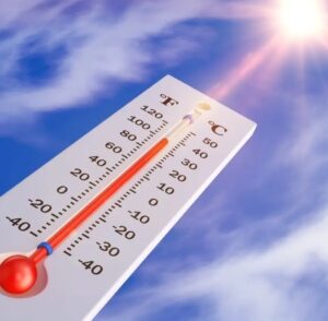
Today’s Outlook: Residents can expect partly sunny skies with a high near 93 degrees Fahrenheit. The most significant concern for today is the heat index, which is projected to soar as high as 99 degrees, making outdoor activities feel considerably hotter and increasing the risk of heat-related illnesses. Showers and thunderstorms are highly likely, mainly concentrated between 4 PM and 5 PM, with a 60% chance of precipitation. New rainfall amounts could range from a tenth to a quarter of an inch, though higher localized totals are possible during stronger thunderstorms. Winds will remain calm, becoming southwest around 5 mph in the afternoon.
Tonight, the chance of showers and thunderstorms diminishes to 30%, primarily before 8 PM. Skies will be partly cloudy, and the low temperature will settle around a muggy 73 degrees with calm winds.
Friday’s Forecast: The region will continue to experience warm conditions on Friday, with a high near 92 degrees. There’s a 40% chance of showers and thunderstorms developing after 1 PM. Winds will remain calm, shifting to a north direction around 5 mph in the afternoon. Friday night brings a 30% chance of showers and thunderstorms, mainly before 7 PM. Skies will be partly cloudy, and the low will be around 70 degrees, with a north wind around 5 mph.
Weekend Weather: The weekend forecast indicates a slight cooling trend but a continued risk of precipitation.
- Saturday: A slight chance of showers before 11 AM, followed by a slight chance of showers and thunderstorms between 11 AM and 2 PM. Showers are likely, and possibly a thunderstorm, after 2 PM. Skies will be partly sunny, with a high near 82 degrees. The chance of precipitation is 60%. An east wind around 5 mph is expected.
- Saturday Night: Showers and thunderstorms are likely before 11 PM, followed by a chance of showers. It will be mostly cloudy, with a low around 68 degrees. The chance of precipitation remains 60%.
- Sunday: A chance of showers and thunderstorms, with showers likely and possibly a thunderstorm after 2 PM. Skies will be mostly cloudy, with a high near 79 degrees. The chance of precipitation is 60%.
Safety Advisories: Given the persistently high heat index values, especially today, residents are strongly advised to take precautions against heat-related illnesses. Stay hydrated by drinking plenty of water, wear light and loose-fitting clothing, and avoid strenuous outdoor activities during the hottest parts of the day. Never leave children or pets unattended in vehicles.
With daily chances of thunderstorms, be mindful of rapidly changing conditions. Seek shelter indoors at the first sign of lightning or thunder, and be aware of localized heavy downpours that could lead to minor urban flooding.
Comments