


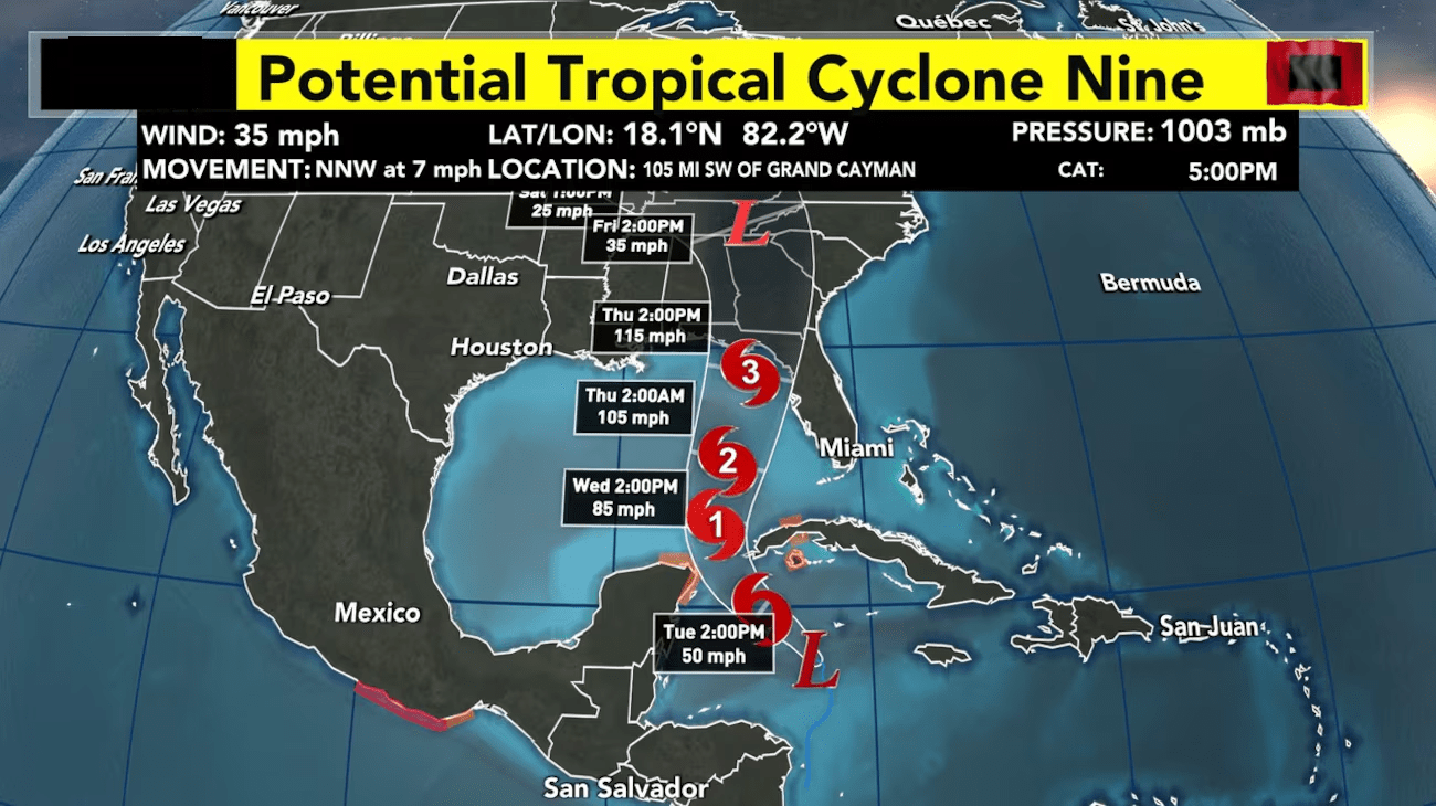
As Potential Tropical Cyclone Nine approaches the northeastern Gulf Coast, forecasters are closely monitoring its potential to rapidly intensify into a major hurricane. The current projections indicate the system will make landfall sometime between Thursday morning and Friday morning, with the most likely scenario being a landfall around 8 PM on Thursday. This fast-moving storm is expected to track to the north and north-northeast, steered by a combination of a mid to upper-level trough to the west and a mid to upper-level ridge to the east.
With several days of consistent ensemble model guidance, confidence is growing in the expected impacts across north and central Georgia. Widespread heavy rainfall is anticipated, with showers and thunderstorms expected to arrive as early as Wednesday night and continuing through Thursday night, before gradually tapering off from south to north on Friday. Rainfall totals are forecast to reach 4-6 inches across the region, with the potential for localized amounts exceeding 7 inches. These heavier rainfall maxima are expected within the strongest rain bands, the precise locations of which can be difficult to pinpoint more than a day in advance. Additionally, the mountainous terrain of north Georgia will enhance the warm rain processes, further contributing to the potential for flash flooding and river flooding. Much of the area along and east of a line from Columbus to Marietta to Gainesville, including the Atlanta metropolitan region, is currently outlined in a Moderate Risk (level 3 of 4) for excessive rainfall, highlighting the significant threat of flash flooding and river flooding during the Thursday morning to Friday morning timeframe.
The fast forward speed and anticipated intensity of the system will also result in strong winds that are likely to persist farther inland than would typically be seen with slower-moving tropical systems. Conditions will gradually become increasingly breezy on Thursday, with the core of the wind field arriving across the southern portions of the forecast area by Thursday evening. As the system tracks farther inland on Thursday night and Friday morning, the winds will strengthen across the entire region, with sustained speeds of 25-35 mph and gusts up to 55 mph, especially near the center of circulation. These strong winds, coupled with the heavy rainfall and resulting moisture-laden soils, raise the risk of widespread tree damage and power line disruptions.
In addition to the heavy rainfall and strong winds, the Storm Prediction Center has introduced a Marginal Risk (level 1 of 5) for tropical cyclone tornadoes across east-central Georgia from Thursday morning to Friday morning. The eastern side of the system’s track will be the most susceptible to the development of low-topped supercells, which can spawn short-lived but potentially damaging tornadoes, due to the tropical air mass and ample low-level shear.
As the system is absorbed into the mid-latitude flow by Friday, it will enhance a broad area of low pressure and troughing over the Southeast through Monday. This setup, combined with the residual tropical moisture, suggests that isolated showers may continue to be a possibility each day. The abundant rainfall and cloud cover throughout the period will also keep high temperatures in the mid-70s to mid-80s, with even cooler temperatures expected in the mountainous regions.
Comments