










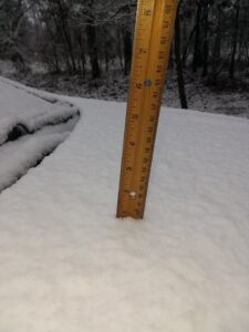
Parts of the WZQZ listening area saw some snow on Sunday – in fact, some folks on Lookout Mountain didn’t get above freezing on Monday and were still dealing with snow on the ground on Tuesday. The good news is, the roads were all clear, even in higher elevations by Sunday evening. Now weather forecasters are telling us that there is the possibility for more winter precipitation as we head towards the end of the week.
A wave of low pressure is expected to form on the front in the northern Gulf of Mexico, and more precipitation will spread northward across Northwest Georgia. There is a chance this could begin in the form of freezing rain for us on Friday morning, where temperatures will be below freezing. Then, later in the day, precipitation is possible in the form of light snow over our area Friday afternoon and Friday night.
Model output remains inconsistent, and forecast confidence remains low. Using the ensemble approach, the European global model shows the chance of 1 inch of snow or greater across our area in 30% – 50% range.
Bottom line is that it is still too early for a specific forecast, but just be aware some winter weather impact is possible Friday and Friday night over our part of the state.
WZQZ will bring you the latest from the National Weather Service and Channel 12 Meteorologist Patrick Core.
Comments