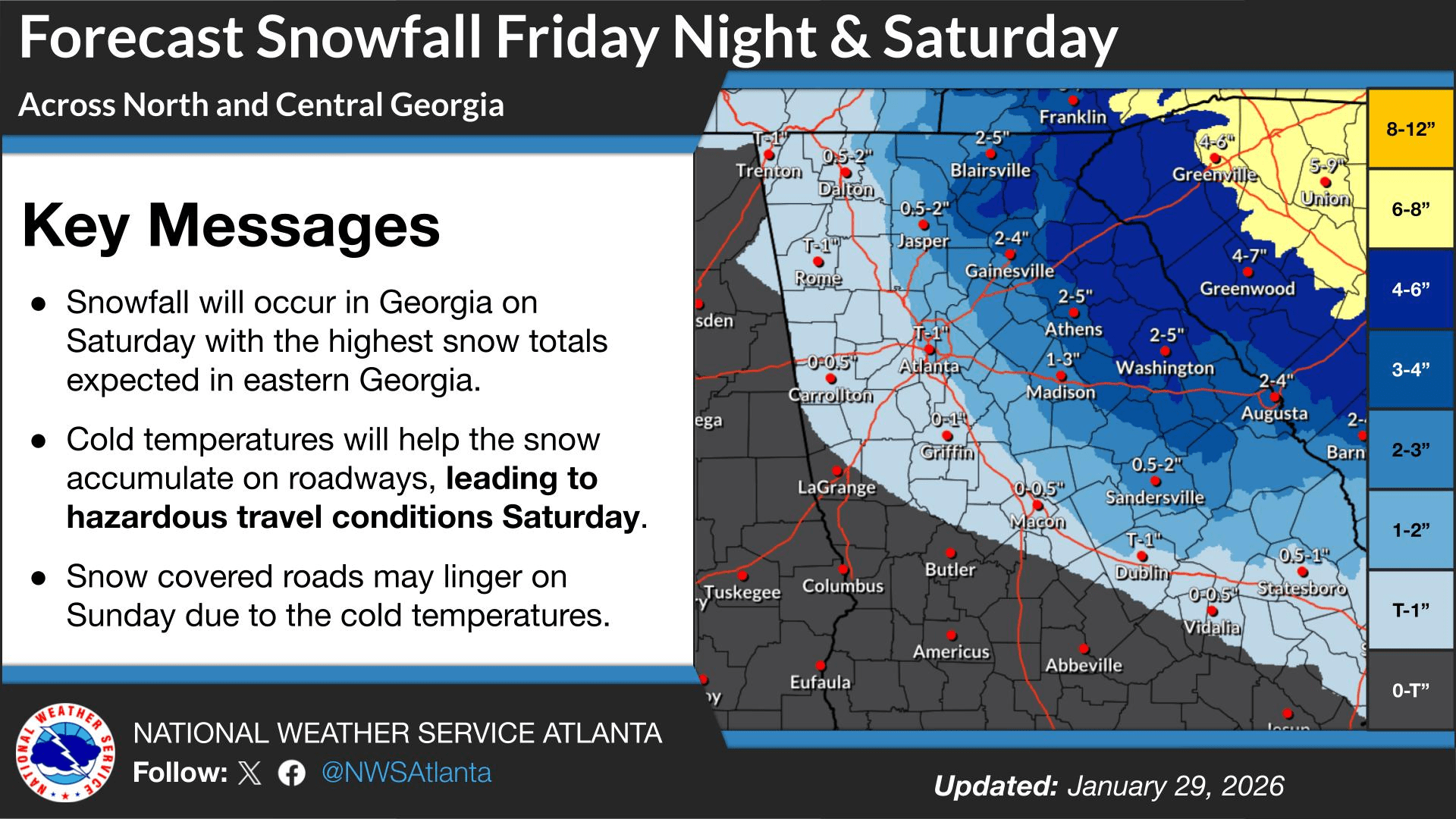
An approaching winter storm is expected to bring heavy snow to portions of the South and northeast Georgia over the next 48 hours. Much like last weekend, Chattooga, Floyd, and Walker Counties will be on the western edge of the expected winter precipitation. The National Weather Service has issued a Winter Weather Advisory for our area, with snow expected Saturday, generally ranging from a dusting to around one inch.
Friday night marks the transition into a more impactful period as a very cold Arctic air mass pushes into the region behind a cold front. Temperatures will fall well below freezing overnight from north to south, while winds become increasingly gusty as the pressure gradient tightens. At the same time, an upper-level trough will deepen and move toward the area, allowing moisture to wrap around the system and produce scattered snow showers across north Georgia. Snow will be possible in our area overnight into Saturday morning, with minor accumulations expected.
The farther east you travel, the greater the likelihood of measurable snowfall, which has prompted a Winter Storm Warning for Northeast Georgia. Snowfall impacts there are expected to be more significant compared to Northwest Georgia.
As conditions begin to clear Saturday night, cold air will rapidly settle in. Winds are expected to remain elevated, causing wind chills to fall into the low single digits. This has led to the issuance of an Extreme Cold Watch from 7 PM Saturday night until 1 PM Sunday afternoon for our area, with the watch expanded to include all of North Georgia.
Temperatures through the first part of next week could remain below freezing for an extended period, increasing concerns for pipes, pets, and people sensitive to extreme cold. Conditions should return to more seasonable, though still cool, weather by Wednesday, with the next weather system expected to arrive midweek. Early indications suggest that system will be warmer than this weekend, with details becoming clearer as this storm exits.
Today
Partly sunny, with a high near 49. Calm wind becoming northwest around 5 mph in the afternoon.
Tonight
A 30 percent chance of snow showers, mainly between midnight and 5am. Mostly cloudy, with a low around 20. North wind 5 to 10 mph, with gusts as high as 25 mph. New snow accumulation of less than a half inch possible.
Saturday
A 30 percent chance of snow showers, mainly between 7am and 1pm. Mostly cloudy, with a high near 27. North wind 10 to 15 mph, with gusts as high as 30 mph. New snow accumulation of less than a half inch possible.
Saturday Night
Mostly cloudy, with a low around 14. Northwest wind 10 to 15 mph, with gusts as high as 30 mph.
Sunday
Sunny, with a high near 37. Northwest wind 5 to 10 mph, with gusts as high as 20 mph.
Sunday Night
Mostly clear, with a low around 18.
Monday
Mostly sunny, with a high near 47.
Monday Night
Mostly clear, with a low around 26.
Tuesday
Partly sunny, with a high near 54.
Tuesday Night
A chance of rain showers before 9pm, then a chance of rain and snow showers between 9pm and 1am, then a chance of rain showers after 1am. Mostly cloudy, with a low around 39. Chance of precipitation is 40%.
Wednesday
Showers likely. Mostly cloudy, with a high near 52. Chance of precipitation is 60%.
Wednesday Night
A 30 percent chance of showers. Mostly cloudy, with a low around 32.


Comments