Sunny and calm weather will continue across north and central Georgia through Saturday, with temperatures quickly warming after a cool, frosty start Friday morning. High pressure will keep skies mostly clear while winds turn southerly, helping afternoon temperatures climb back into the 70s and even low 80s by Saturday — well above normal for mid-March.
An Extreme Cold Warning remains in effect through this afternoon for Chattooga County and much of north and central Georgia as a deep arctic air mass drives dangerously low wind chills across the region. Most of Chattooga County only saw a light dusting of snow, but higher elevations on Lookout Mountain picked up around 1 to 2 inches, and the bitter cold and gusty winds could keep slick spots lingering in a few areas. Temperatures trend warmer early this week, with rain chances returning midweek before another cool down.
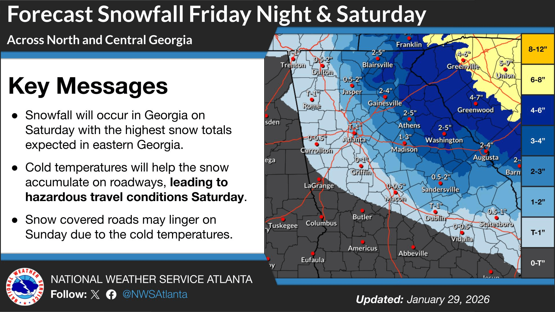
A winter storm moving across parts of Tennessee, Georgia, and the Carolinas will be the main weather story over the next 24 to 48 hours, with widespread snowfall expected across portions of the region. Forecasters say confidence is high in the overall setup: an unusually strong upper-level low dropping out of Canada will drive a surge of Arctic air into the Southeast, while a surface low strengthens rapidly off the Georgia and South Carolina coast. As that coastal system intensifies, moisture will wrap back into Georgia, combining with lift from the upper-level low to produce snow—though where the western edge of the snow sets up remains one of the biggest uncertainties.
An approaching winter storm is expected to bring heavy snow to portions of the South and northeast Georgia over the next 48 hours. Much like last weekend, Chattooga, Floyd, and Walker Counties will be on the western edge of the expected winter precipitation. The National Weather Service has issued a Winter Weather Advisory for our area, with snow expected Saturday, generally ranging from a dusting to around one inch.
Once again, Georgia and much of the Deep South appear headed for a round of winter weather this weekend, but like last weekend, the best chance for frozen precipitation looks to stay mainly east of Chattooga, Floyd, and Walker Counties. The National Weather Service says confidence continues to increase for measurable snowfall across parts of northeast and east-central Georgia between Friday night and Saturday night, prompting a Winter Storm Watch for those areas.
A developing winter storm is expected to affect parts of the Southeast and Mid-Atlantic late Friday night into Saturday morning, bringing the potential for heavier snow and travel impacts mainly to areas east of Northwest Georgia. Forecast guidance continues to point the most significant winter weather toward the eastern Carolinas and into southern Virginia, with confidence increasing for impactful snowfall in those regions.
The potential is increasing for another significant winter storm to impact parts of the eastern United States this coming weekend. Forecasters emphasize it is still too early to pin down exact details, but confidence is growing that a storm system could develop and move through while very cold air remains in place.
Meteorologists say a disturbance is expected to move out of Canada later this week, helping a stronger low-pressure system form across the East. If that system tracks in the right corridor, it could bring widespread precipitation that may fall as rain, snow, or a mix, depending on where the coldest air sets up. The biggest uncertainties right now include the storm’s timing, track, and strength, which will determine what areas see the greatest impacts.
For Northwest Georgia and the surrounding region, the message for now is preparedness without panic. Residents should keep checking updated forecasts through the week, especially as we get closer to Friday and Saturday when forecast confidence typically improves. Now is also a good time to review weekend travel plans, make sure you have supplies in case of slick roads or power issues, and plan ahead for pets, pipes, and outdoor needs if colder, wetter conditions move in.
Cold weather can be dangerous for pets, with real risks of hypothermia and frostbite—especially for short-haired, small, elderly, or sick animals. The safest plan is simple: keep pets indoors as much as possible, limit time outside, and take a few extra precautions when they do go out.
Georgia is on high alert as an impending winter storm approaches, and while much of North Georgia will see frozen precipitation over the next 48 hours, Northwest Georgia’s risk remains lower than areas to the east. Expect cloudy skies and periods of light rain today, a brief wintry mix potential Saturday morning before changing back to rain, the highest concern for freezing rain Saturday night into Sunday morning (especially on Lookout Mountain), and then the bigger story: bitterly cold Arctic air arriving to start next week.
An Arctic front moving into the Southeast will bring some of the coldest air of the season to Chattooga County and the rest of Northwest Georgia Sunday into Monday, before temperatures rebound quickly during the second half of the week.