Chattooga County Schools Cancel Extracurricular Activities Due to Expected Snow

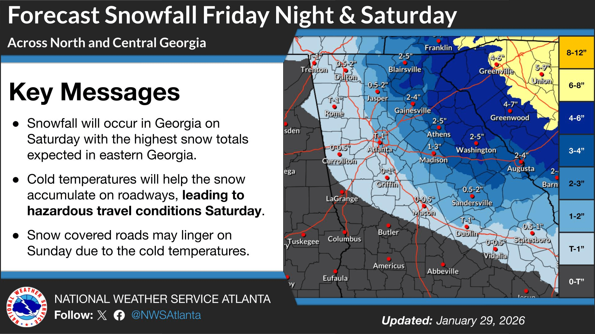
Chattooga County Schools have canceled all extracurricular activities scheduled for tonight, Friday, January 30, 2026, as well as events planned for this weekend, due to the forecast for snow beginning tonight and continuing into Saturday. School officials said information on rescheduled dates and times will be shared once details are confirmed.

The announcement was issued by Jeremy Heathcock with Chattooga County Schools, who encouraged families to stay warm and safe as winter weather moves into the area.

Update: Winter Storm Targets Georgia; Light Snow Possible in Chattooga, Floyd and Walker Counties as Dangerous Cold Arrives

A winter storm moving across parts of Tennessee, Georgia, and the Carolinas will be the main weather story over the next 24 to 48 hours, with widespread snowfall expected across portions of the region. Forecasters say confidence is high in the overall setup: an unusually strong upper-level low dropping out of Canada will drive a surge of Arctic air into the Southeast, while a surface low strengthens rapidly off the Georgia and South Carolina coast. As that coastal system intensifies, moisture will wrap back into Georgia, combining with lift from the upper-level low to produce snow—though where the western edge of the snow sets up remains one of the biggest uncertainties.

Read more

Chance of Light Snow, Then Dangerous Arctic Cold Across Northwest Georgia

WINTER WEATHER ADVISORY  7 PM Friday – 7 PM Saturday

EXTREME COLD WATCH 7 PM Saturday – 1 PM Sunday

An approaching winter storm is expected to bring heavy snow to portions of the South and northeast Georgia over the next 48 hours. Much like last weekend, Chattooga, Floyd, and Walker Counties will be on the western edge of the expected winter precipitation. The National Weather Service has issued a Winter Weather Advisory for our area, with snow expected Saturday, generally ranging from a dusting to around one inch.

Read more

Winter Storm Watch Expanded for Northwest Georgia: Lookout Mountain Faces Higher Ice and Snow Risk While Valleys Prepare for Dangerous Travel Into Monday

A Winter Storm Watch is now in effect for a large portion of North and Northwest Georgia, including Chattooga and Walker County areas, from late Friday night through Monday morning. The National Weather Service says heavy mixed precipitation is possible during that time, with total snow and sleet accumulations up to four inches and ice accumulations greater than one quarter of an inch also possible.

Read more

Winter Weather Possibilities Should Be Monitored Between Now and the Weekend

A Winter Storm Watch has been issued for Mentone, Alabama from Friday evening through Sunday afternoon, and forecasters say the same storm system could bring significant winter weather impacts into Northwest Georgia—especially the higher elevations on Lookout Mountain in Chattooga and Walker Counties, where communities like Cloudland often see conditions more similar to Mentone than the valleys below.

Read more