










A familiar summertime pattern will continue across Chattooga County and Northwest Georgia this weekend, with hot and humid afternoons accompanied by scattered showers and thunderstorms.

A familiar summertime pattern will continue across Chattooga County and Northwest Georgia this weekend, with hot and humid afternoons accompanied by scattered showers and thunderstorms.
Another hot and humid August afternoon is ahead across Chattooga County and Northwest Georgia, with scattered showers and thunderstorms expected to develop as temperatures climb.
Another round of scattered showers and thunderstorms is expected across Chattooga County and northwest Georgia today, continuing a familiar summertime pattern that will bring afternoon storms and increasing heat through the coming week.
Scattered showers and thunderstorms are expected to develop again across Chattooga County and Northwest Georgia this afternoon, bringing the potential for gusty winds, heavy rainfall and localized flash flooding.
Residents across Chattooga County and Northwest Georgia can expect another stretch of typical summer weather this week, with warm afternoons and scattered showers and thunderstorms developing each day.
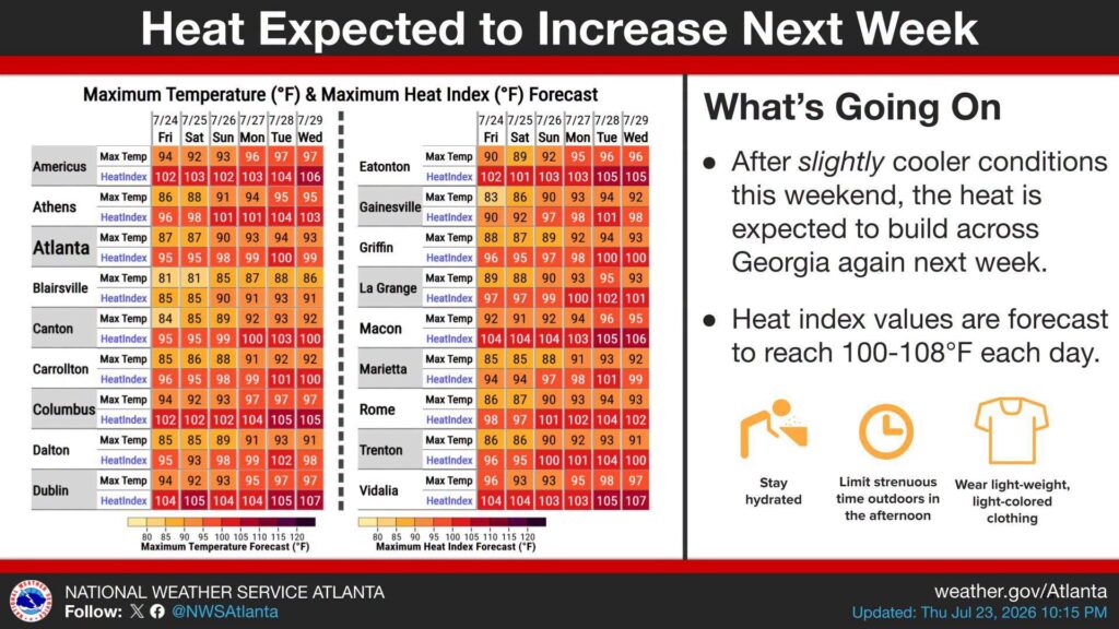
While showers and thunderstorms will keep temperatures a little lower through the weekend, much hotter weather is expected to return to northwest Georgia next week.
Highs in Chattooga County are forecast to climb into the lower 90s on Sunday, then reach the middle 90s by Tuesday. Heat index values are expected to top 100 degrees each afternoon, making it feel even hotter.
The National Weather Service says the hottest conditions are expected Monday through Wednesday as high humidity combines with the summer heat. Residents are encouraged to stay hydrated, wear light-colored clothing, limit strenuous outdoor activities during the hottest part of the day, and check on elderly neighbors, children and pets.
While a slight chance of afternoon thunderstorms remains in the forecast next week, widespread relief from the heat is not expected.

Northwest Georgia will experience another hot day today before showers and thunderstorms become more widespread later this week.
Today will be mostly sunny with a high near 94 degrees. Heat index values could reach 100 during the afternoon. Winds will be calm early before becoming southerly at around 5 mph. Tonight will be mostly cloudy with a low near 75.
A cold front approaching from the north will bring a return to more active weather on Wednesday. The day will be partly sunny with a high near 91 and heat index values again approaching 100. There is a 30 percent chance of showers and thunderstorms, mainly after 5 p.m.
Rain and storm chances increase to 60 percent Wednesday night as the front settles into north Georgia. Some storms could produce heavy rainfall, frequent lightning and strong wind gusts. Localized flash flooding could become a concern where storms repeatedly move across the same areas.
Temperatures will become slightly cooler Thursday and Friday, with highs in the middle to upper 80s. Scattered showers and thunderstorms will remain possible both days.
Saturday currently has the highest chance of rain, with showers and thunderstorms likely and a 70 percent chance of precipitation. Highs will remain in the upper 80s before warming back to around 90 Sunday and the lower 90s by Monday.
Tropical Storm Bertha will continue moving slowly westward across the northern Gulf of Mexico. The storm is not expected to bring any direct impacts to Northwest Georgia, though increasing moisture and the approaching front will contribute to higher rain chances later this week.
A typical summertime weather pattern returns to Chattooga County and northwest Georgia Thursday, bringing hot and humid conditions along with another chance of afternoon showers and thunderstorms.
Northwest Georgia will continue to experience warm, humid weather with daily opportunities for afternoon and evening thunderstorms through at least early next week, according to the National Weather Service.

Residents of Chattooga County and northwest Georgia can expect another unsettled day of weather Tuesday as a slow-moving weather system continues to bring widespread showers and thunderstorms across the region. While the soaking rainfall has helped ease the recent stretch of extreme heat, forecasters say the pattern will gradually transition back to typical summertime conditions later this week, with temperatures climbing into the 90s and heat index values once again approaching or exceeding 100 degrees.