


![]()
Northwest Georgia will continue to experience warm, humid weather with daily opportunities for afternoon and evening thunderstorms through at least early next week, according to the National Weather Service.

![]()
Northwest Georgia will continue to experience warm, humid weather with daily opportunities for afternoon and evening thunderstorms through at least early next week, according to the National Weather Service.

Residents of Chattooga County and northwest Georgia can expect another unsettled day of weather Tuesday as a slow-moving weather system continues to bring widespread showers and thunderstorms across the region. While the soaking rainfall has helped ease the recent stretch of extreme heat, forecasters say the pattern will gradually transition back to typical summertime conditions later this week, with temperatures climbing into the 90s and heat index values once again approaching or exceeding 100 degrees.
Residents across Chattooga County and northwest Georgia should prepare for a wet start to the week as a slow-moving weather system brings numerous showers and thunderstorms through Tuesday before conditions gradually return to a more typical summertime pattern later in the week.
![]()
Hot and humid conditions will continue across Chattooga County and northwest Georgia this weekend, but increasing thunderstorm activity is expected to bring periods of heavy rain and some relief from the heat.
![]()
After another hot summer morning, weather conditions across Chattooga County and northwest Georgia are expected to become increasingly active this afternoon as a series of disturbances brings a higher chance of showers and thunderstorms through the weekend and into early next week.
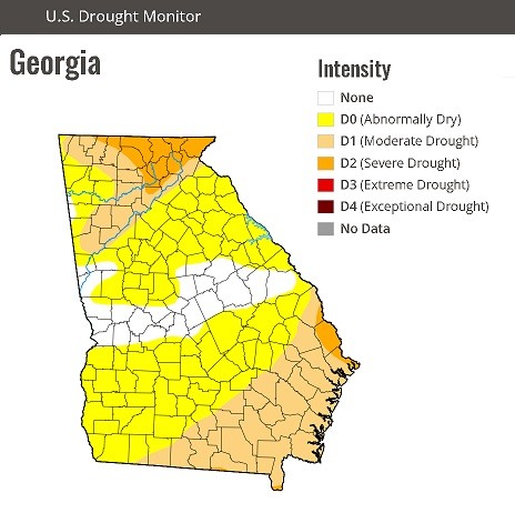
Recent rainfall has lowered the immediate wildfire threat across Northwest Georgia, but the latest U.S. Drought Monitor shows Chattooga, Floyd and Walker counties remain Abnormally Dry, indicating the region has not fully recovered from recent dry conditions.
![]()
Summer weather will continue across Chattooga County and northwest Georgia today with mostly sunny skies and a high near 90 degrees. After a dry start, a 30 percent chance of scattered showers and thunderstorms develops after 2 p.m. Light winds will become westerly around 5 miles per hour during the afternoon before calming again tonight. Any storms that develop should diminish by early evening, with overnight lows falling to around 71.
![]()
Hot summer weather will continue across Chattooga County and Northwest Georgia this week, with temperatures climbing into the lower 90s each afternoon and the daily chance of scattered thunderstorms remaining in the forecast.
![]()
Residents across Chattooga County and Northwest Georgia should prepare for another hot and humid day today, with scattered afternoon and evening thunderstorms expected to develop.
![]()
Those planning to celebrate Independence Day outdoors across Chattooga County and Northwest Georgia should prepare for another day of dangerous heat, with only a slight chance of an afternoon thunderstorm.
Today will be sunny and very hot with a high near 96 degrees. Heat index values are expected to climb as high as 102 degrees during the afternoon. While an isolated shower or thunderstorm could develop after 2 p.m., mainly along the Alabama state line and in parts of far northwest Georgia, most communities are expected to remain dry through much of the day. A few additional thunderstorms will be possible Saturday evening before skies become partly cloudy overnight.
The National Weather Service says heat remains the biggest concern. “Feels like” temperatures are expected to exceed 90 degrees by around 10 a.m. and may not fall below that level until nearly 11 p.m., making it uncomfortably hot even after sunset. Anyone attending parades, cookouts, ballgames, fireworks displays, or other outdoor events should drink plenty of water, take frequent breaks in the shade or air conditioning, wear light-colored clothing, and check on children, older adults, and pets.
Rain chances increase beginning Sunday as the weather pattern becomes more typical for early July. Afternoon and evening showers and thunderstorms are expected Sunday through at least Friday, with daily rain chances ranging from 40 to 60 percent. High temperatures will ease slightly into the lower 90s by early next week, but humidity will keep heat index values in the upper 90s to around 100 degrees each afternoon.
Anyone spending time outdoors over the holiday weekend should continue to monitor the forecast, especially if thunderstorms develop later in the weekend.