










Residents across Chattooga County can expect one more stretch of summer-like temperatures before a strong cold front brings a significant change in the weather this weekend.

Residents across Chattooga County can expect one more stretch of summer-like temperatures before a strong cold front brings a significant change in the weather this weekend.

Residents across Chattooga County can expect another unusually warm October day today, with temperatures climbing into the upper 80s before a strong cold front brings much cooler weather to Northwest Georgia this weekend.
Residents across Chattooga County can expect several more days of sunshine and unseasonably warm temperatures before a strong cold front brings a significant change in the weather this weekend.
Residents of Chattooga County and Northwest Georgia can expect a stretch of sunny skies and unseasonably warm temperatures this week, with afternoon highs climbing into the upper 80s before a strong cold front brings much cooler weather for the weekend.
Residents across Chattooga County can expect improving weather conditions Sunday as the remnants of Post-Tropical Cyclone Isaias continue moving away from Northwest Georgia following Saturday’s heavy rainfall, strong winds and storm damage.

Chattooga County residents are facing a potentially dangerous weather situation Saturday as Hurricane Isaias brings strong winds, heavy rainfall and the threat of severe storms to Northwest Georgia.
Residents across Chattooga County and Northwest Georgia are being urged to prepare for a potentially dangerous weekend as Hurricane Isaias approaches the northern Gulf Coast, bringing the threat of damaging winds, flooding and tornadoes to the region.
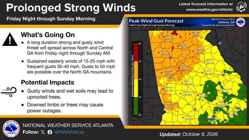
The National Weather Service in Peachtree City is warning residents across Chattooga County and Northwest Georgia to prepare for an extended period of strong, gusty winds beginning Friday night and continuing through Sunday morning.

Residents across Chattooga County and Northwest Georgia are being urged to prepare for a potentially dangerous weekend of weather as Hurricane Isaias approaches the northern Gulf Coast.
Chattooga County will see another warm and dry day today, but residents should keep an eye on the forecast as a tropical system moving toward the Gulf Coast could bring heavy rain, gusty winds and possibly severe weather to Northwest Georgia this weekend.