


![]()
Northwest Georgia will get a little break from the heavier coverage of showers and storms today and Thursday, but the rainy pattern is far from over.

![]()
Northwest Georgia will get a little break from the heavier coverage of showers and storms today and Thursday, but the rainy pattern is far from over.
![]()
Chattooga County and the rest of Northwest Georgia are heading into a hot, humid, and stormy stretch of weather that will continue through Memorial Day weekend and into early next week.
![]()
Dry weather is expected to continue across northwest Georgia through Friday as high pressure remains in control of the region.
![]()
Northwest Georgia will enjoy cooler temperatures Friday before a warming trend settles in over the weekend, but rain and thunderstorms are expected to return beginning Saturday and continuing into Sunday. Forecasters say another half-inch to two inches of rain could fall across portions of the region through the weekend.
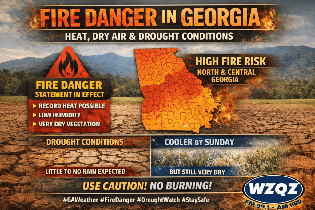
A Fire Danger Statement remains in effect across portions of north and central Georgia as dry vegetation, low humidity, and unusually warm temperatures continue to create dangerous fire weather conditions through the end of the week.

A Fire Danger Statement is in effect this afternoon across Chattooga County and Northwest Georgia as very dry, warm conditions continue to raise wildfire concerns across the region.
![]()
Drivers in Chattooga County and across Northwest Georgia could see reduced visibility this morning as isolated areas of patchy fog drop visibility below a half mile in some spots. Conditions are expected to improve by around 10 a.m.
![]()
Chattooga County and much of Northwest Georgia are waking up to a mild and slightly damp start this Tuesday, with brief sprinkles and patchy fog possible through the morning hours—especially in low-lying areas and near rivers and creeks. Little to no accumulation is expected, but reduced visibility could impact early travel.
![]()
A noticeable warm-up is underway across Chattooga County and Northwest Georgia, with springlike heat building Tuesday and daily rain chances settling in through the weekend.
![]()
A cold front moving through the region will bring a return to more seasonal temperatures across Chattooga County and Northwest Georgia by Tuesday, with only minimal rain expected in the short term.