









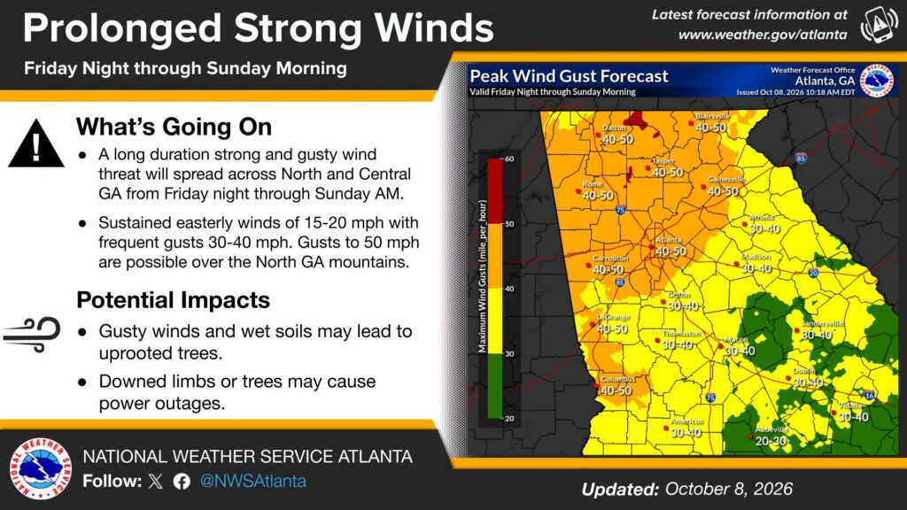
The National Weather Service in Peachtree City is warning residents across Chattooga County and Northwest Georgia to prepare for an extended period of strong, gusty winds beginning Friday night and continuing through Sunday morning.

The National Weather Service in Peachtree City is warning residents across Chattooga County and Northwest Georgia to prepare for an extended period of strong, gusty winds beginning Friday night and continuing through Sunday morning.

Residents across Chattooga County and Northwest Georgia are being urged to prepare for a potentially dangerous weekend of weather as Hurricane Isaias approaches the northern Gulf Coast.

Northwest Georgia will remain dry and warm through Friday, but forecasters are closely watching a tropical system in the Gulf that could bring significant rainfall, gusty winds and thunderstorms to the region this weekend.
The National Weather Service says Tropical Depression Nine has formed in the Gulf, although considerable uncertainty remains concerning its eventual track and the extent of its impacts on Georgia.
For Thursday, Chattooga County can expect sunny skies with a high near 87 degrees. Thursday night will be mostly clear with a low around 58.
Friday will remain mostly sunny with a high near 85, but conditions could begin changing Friday night as moisture associated with the tropical system moves northward. A slight chance of showers develops after 2 AM.
Rain chances increase to 50% Saturday, with a high near 75. Showers become likely Saturday night, when thunderstorms will also be possible and rain chances increase to 70%.
Showers are likely again Sunday, with thunderstorms possible during the afternoon. Sunday’s high will be near 74 degrees, with a 70% chance of precipitation.
The National Weather Service says current projections indicate one to three inches of rainfall could fall across portions of north and central Georgia, although amounts will depend heavily on the eventual track of the tropical system.
Forecasters say sustained winds around 15 mph with gusts potentially reaching 25 to 30 mph are also possible. Heavy rainfall could produce localized flash flooding and rises along rivers, creeks and streams.
There could also be a tornado threat depending on the system’s eventual track and strength.
Forecasters emphasize that considerable uncertainty remains regarding the timing, location and intensity of the system. Residents are encouraged to monitor updated forecasts as the weekend approaches.
Conditions should gradually improve early next week as the tropical system weakens and a drier air mass moves into the region.

A wet and cloudy Sunday is in store for Chattooga County before a cold front brings several days of drier and more fall-like weather to Northwest Georgia.
Chattooga County will close out September with sunshine and temperatures well above normal, but a major change in the weather pattern is expected by the weekend.
The National Weather Service says Wednesday will be sunny with a high near 89 degrees. Winds will be light, becoming southeast around 5 mph during the afternoon. Wednesday night will be mostly clear with a low around 61.
Forecasters say Wednesday’s temperatures across the region will run approximately 8 to 12 degrees above normal for the final day of September.
The warm weather continues Thursday with sunshine and a high near 90. Friday could be even warmer, with a high near 91 before moisture begins returning to the area. A 30% chance of showers develops Friday afternoon, increasing to 50% Friday night.
A much wetter pattern is expected for the weekend.
The chance of rain increases to 70% Saturday, with showers likely and thunderstorms possible during the afternoon. Rain chances climb to 80% Saturday night and Sunday.
The National Weather Service says Sunday will need to be watched for the possibility of stronger thunderstorms as a weather system moves through the region. Forecasters caution that details concerning the strength of the storms could change as the weekend gets closer.
Heavy rainfall could also become a concern. Current guidance indicates several inches of rain could be possible from Friday into early next week, potentially creating a risk of flash flooding in parts of north Georgia.
Temperatures will turn noticeably cooler behind the system. Sunday’s high is forecast near 78, followed by highs around 76 Monday and 74 Tuesday.
A dry start to the week will give way to summerlike temperatures across Chattooga County before rain and thunderstorms return for the weekend.
A stretch of pleasant, dry weather will continue across Chattooga County through the first part of the week, but temperatures are expected to climb back toward summerlike levels by midweek.
Residents across Chattooga County can expect a taste of fall this weekend, with cooler temperatures, lower humidity and plenty of sunshine before warmer weather begins returning next week.
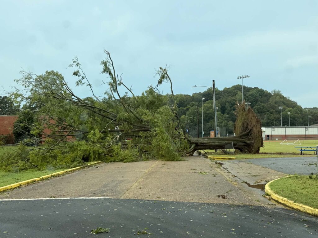
The damaging storm that struck Trion Monday afternoon was not a tornado, according to the National Weather Service, but rather a downburst, likely a wet microburst, capable of producing winds estimated at 60 to 70 mph.
An extended stretch of hot, mostly sunny and unusually dry weather will continue across Chattooga County and Northwest Georgia through Saturday, with temperatures remaining well above normal for the middle of September.