


![]()
Northwest Georgia residents can expect a stretch of cooler-than-normal temperatures and daily opportunities for showers and thunderstorms through the upcoming weekend, according to the National Weather Service.

![]()
Northwest Georgia residents can expect a stretch of cooler-than-normal temperatures and daily opportunities for showers and thunderstorms through the upcoming weekend, according to the National Weather Service.
![]()
Northwest Georgia will stay warm through the middle of next week, with afternoon highs expected to climb into the mid to upper 80s across much of the area.
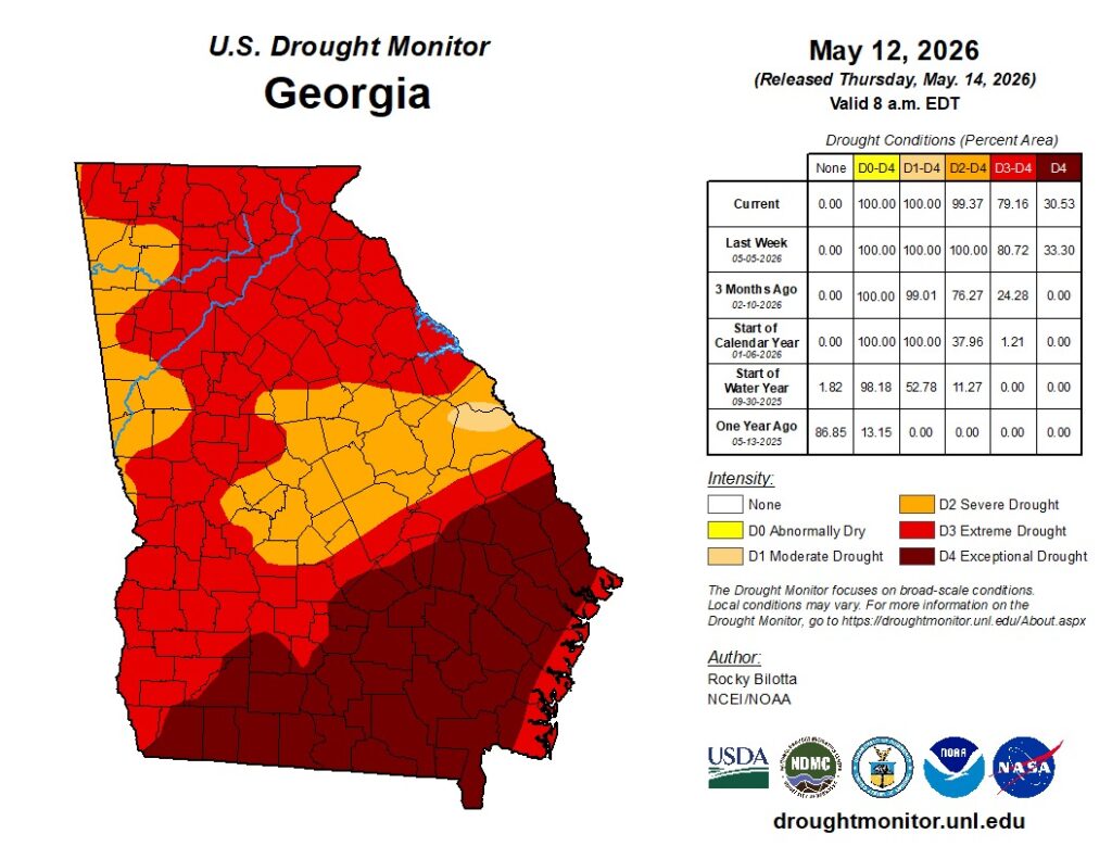
Even with several rounds of recent rainfall across northwest Georgia, drought conditions continue to grip Chattooga County and much of the Southeast.
According to the latest U.S. Drought Monitor, Chattooga County remains in drought conditions, with officials saying recent rain has provided only limited relief to extremely dry soil and low streamflow levels.
Weather experts say the region remains well below normal rainfall totals over the past several months, and ongoing dry conditions have continued to elevate wildfire danger across Georgia and neighboring states.
The National Drought Mitigation Center reports that much of Georgia remains in moderate to severe drought categories despite scattered rain events in recent weeks. Forecasters say isolated showers may temporarily improve surface conditions, but more widespread and sustained rainfall will be needed before meaningful drought recovery occurs.
Recent dry weather has also contributed to elevated fire weather concerns across north Georgia, with low humidity and dry vegetation increasing the risk for brush fires and wildfires.
Meteorologists say warmer temperatures expected over the coming days could worsen evaporation rates and place additional stress on already dry ground conditions.
![]()
Dry weather is expected to continue across northwest Georgia through Friday as high pressure remains in control of the region.

Sunny and calm weather will continue across north and central Georgia through Saturday, with temperatures quickly warming after a cool, frosty start Friday morning. High pressure will keep skies mostly clear while winds turn southerly, helping afternoon temperatures climb back into the 70s and even low 80s by Saturday — well above normal for mid-March.

Residents in Chattooga County and across Northwest Georgia can expect a stretch of unseasonably warm weather heading into the weekend and early next week, with temperatures running 15 to more than 20 degrees above normal for early March.
A Fire Danger Statement remains in effect for all of north and central Georgia, including Chattooga County and surrounding Northwest Georgia communities, until 6PM today due to low relative humidity levels and dry conditions.
Residents across Chattooga County and Northwest Georgia are experiencing an early taste of spring as temperatures climb well above normal for early February. Forecasters say highs will run 10 to 15 degrees above average for the next few days before gradually cooling back toward seasonal levels later this week.

Unseasonably warm weather continues to dominate the pattern across Chattooga County and the rest of Northwest Georgia, and this trend shows no signs of breaking anytime soon. Temperatures, already well above what is typical for late November, are expected to remain elevated through at least the middle of next week. In fact, several days may come close to setting new record highs as the region remains locked under stubbornly warm air.

Northwest Georgia residents awoke to pleasant temperatures in the 60s this morning, accompanied by partly cloudy skies. While the morning clouds are expected to give way to sunshine by late afternoon, there remains a slight chance (20%) of a thunderstorm developing later today. Winds are currently blowing from the southeast between 5 and 15 mph, with potential gusts reaching up to 30 mph. Temperatures are on the rise, with highs today expected to be around 83 degrees, warmer than Tuesday’s conditions. Looking ahead, tonight will bring cloudy conditions and a low around 65 degrees. A south wind will persist at 5 to 10 mph, with gusts potentially reaching 25 mph. The trend of above-average temperatures will continue through Saturday, with highs expected to linger in the upper 80s to low 90s. However, relief is on the horizon. Rain is expected to return on Sunday, bringing with it a significant cool-down. The first part of next week will see highs in the 60s and lows dipping into the upper 30s, marking a noticeable change in weather patterns for the region.