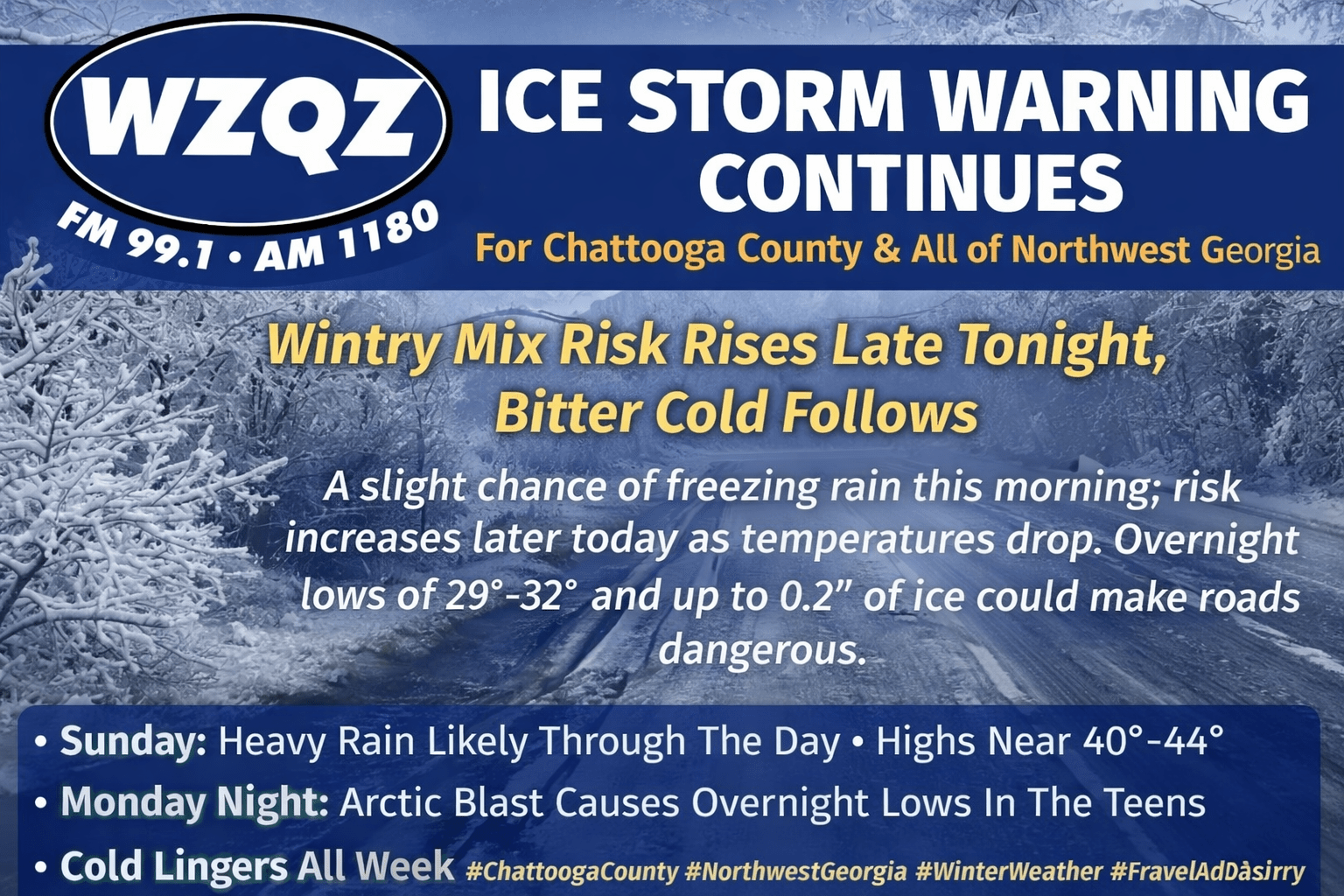
Much of Georgia is starting this Sunday morning, January 25, 2026, with freezing rain and sleet, but for folks here in Chattooga County and much of Northwest Georgia, the main issue early today has been heavy rain. Temperatures around daybreak were near to slightly above freezing, helping keep most roads wet instead of icy to start the morning. Even so, the steady rainfall can still create hazardous travel, especially with reduced visibility, standing water in low spots, and slick conditions where oil and debris collect on the roadway.
While Chattooga County and all of Northwest Georgia remain under an Ice Storm Warning, the National Weather Service forecast for our area is calling for only a slight chance of freezing rain before 10 AM this morning. Early temperatures were running marginal for widespread icing, with LaFayette and Mentone hovering just below freezing at 31 degrees, while Gaylesville, Alabama and Rome were closer to 40. Summerville was sitting at 35 degrees. Those readings are a bit warm for freezing rain in many spots, but sleet could still fall anywhere across the area, especially in heavier bursts of precipitation.
A high-impact winter storm is expected to bring significant icing to Chattooga County and parts of Northwest Georgia this weekend, prompting the National Weather Service to issue an Ice Storm Warning. The warning is in effect from 7:00 AM Saturday until 10:00 AM Monday.
Georgia is on high alert as an impending winter storm approaches, and while much of North Georgia will see frozen precipitation over the next 48 hours, Northwest Georgia’s risk remains lower than areas to the east. Expect cloudy skies and periods of light rain today, a brief wintry mix potential Saturday morning before changing back to rain, the highest concern for freezing rain Saturday night into Sunday morning (especially on Lookout Mountain), and then the bigger story: bitterly cold Arctic air arriving to start next week.
Forecasters say a high-impact winter storm is increasingly likely across Georgia this weekend, with freezing rain and ice expected to be the primary hazards and the potential for widespread power outages and dangerous travel conditions. The Winter Storm Watch has been expanded to include most of North Georgia and a small portion of Central Georgia, with the watch starting 1:00 AM Saturday for the far northern tier and beginning 1:00 PM Saturday for areas generally near and south of I-20. Both time periods extend through 10:00 AM Monday.
A high-impact winter storm is expected to move into northern Georgia this weekend, and forecasters say the biggest concerns for Northwest Georgia are ice, dangerous travel, and possible power outages. A Winter Weather Watch begins at 1:00 a.m. Saturday and continues into Monday morning as multiple storm systems interact with a surge of Arctic air pushing south.
A Winter Storm Watch is now in effect for a large portion of North and Northwest Georgia, including Chattooga and Walker County areas, from late Friday night through Monday morning. The National Weather Service says heavy mixed precipitation is possible during that time, with total snow and sleet accumulations up to four inches and ice accumulations greater than one quarter of an inch also possible.


