


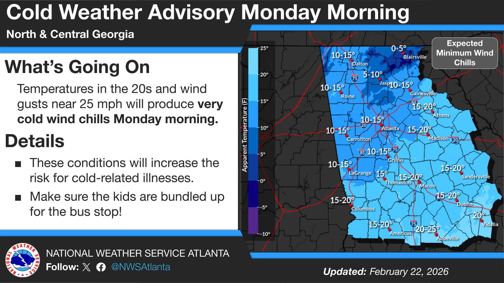
Residents across Chattooga County and Northwest Georgia are facing a double dose of winter weather as a Wind Advisory remains in effect until 7 p.m. Sunday, followed by a Cold Weather Advisory from 1 a.m. to 10 a.m. Monday.

Residents across Chattooga County and Northwest Georgia are facing a double dose of winter weather as a Wind Advisory remains in effect until 7 p.m. Sunday, followed by a Cold Weather Advisory from 1 a.m. to 10 a.m. Monday.


Residents across Chattooga County and Northwest Georgia will enjoy unseasonably warm temperatures today ahead of an approaching cold front that will bring widespread light rain to the region later this evening through Wednesday.

In his latest legislative report, State Rep. Eddie Lumsden says the Georgia House returned to full work after Winter Storm Fern prompted a State of Emergency and briefly slowed the start of the 2026 session. Lumsden, a Republican from Armuchee, represents Chattooga County and a portion of Floyd County in the Georgia House of Representatives.
Lumsden says House Appropriations subcommittees resumed meetings to review the AFY 2026 and FY 2027 budget proposals, while the House Rules Committee met for the first time this session and the chamber passed its first legislation of 2026. He also noted lawmakers recognized utility crews, first responders, and agencies for storm response and power restoration efforts across North Georgia.
Among key actions, the House passed HB 443 to create offshore fishing endorsement fees to support Georgia-based fisheries surveys, and unanimously adopted HR 1008 to update the state’s water planning council structure. Lumsden also cited final passage of SB 148, which would update public school policies including hunting safety lessons, outdoor learning, expanded personal leave, and changes to AED program requirements. He added that House Speaker Jon Burns introduced the Georgia HOME Act, a proposal aimed at phasing out homestead property taxes by 2032.
You can read Rep. Lumsden’s complete report below:

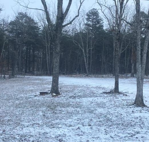
An Extreme Cold Warning remains in effect through this afternoon for Chattooga County and much of north and central Georgia as a deep arctic air mass drives dangerously low wind chills across the region. Most of Chattooga County only saw a light dusting of snow, but higher elevations on Lookout Mountain picked up around 1 to 2 inches, and the bitter cold and gusty winds could keep slick spots lingering in a few areas. Temperatures trend warmer early this week, with rain chances returning midweek before another cool down.

Bethlehem Baptist Church
Mount Calvary Baptist Church at Cloudland
Second Baptist Church in Summerville
Faith Baptist Church in Menlo
Trion Evangelical Presbyterian Church
Teloga Baptist Church
Faith Worship Center in LaFayette
LaFayette First United Methodist Church
Fisher’s Chapel Church
Trion Heights Baptist Church
Menlo Methodist Church
Subligna Baptist Church – No Sunday School / Will be having Worship Service
Perennial Springs Baptist Church
Bethel Methodist Church in Gore
Harrell Street Church of God in Trion
Chattooga County Commissioner Andy Allen says crews are starting to see minor accumulation on some roads, but nothing serious at this time. He says county work crews are out treating a few locations in the northern end of the county and in higher elevations, and another update is expected later this afternoon.
While the heaviest snowfall is expected to remain east of our area, Chattooga, Floyd, and Walker Counties in Northwest Georgia will see light snow showers this morning, according to the National Weather Service in Peachtree City.
![]()
Chattooga County Schools have canceled all extracurricular activities scheduled for tonight, Friday, January 30, 2026, as well as events planned for this weekend, due to the forecast for snow beginning tonight and continuing into Saturday. School officials said information on rescheduled dates and times will be shared once details are confirmed.
The announcement was issued by Jeremy Heathcock with Chattooga County Schools, who encouraged families to stay warm and safe as winter weather moves into the area.
A winter storm moving across parts of Tennessee, Georgia, and the Carolinas will be the main weather story over the next 24 to 48 hours, with widespread snowfall expected across portions of the region. Forecasters say confidence is high in the overall setup: an unusually strong upper-level low dropping out of Canada will drive a surge of Arctic air into the Southeast, while a surface low strengthens rapidly off the Georgia and South Carolina coast. As that coastal system intensifies, moisture will wrap back into Georgia, combining with lift from the upper-level low to produce snow—though where the western edge of the snow sets up remains one of the biggest uncertainties.