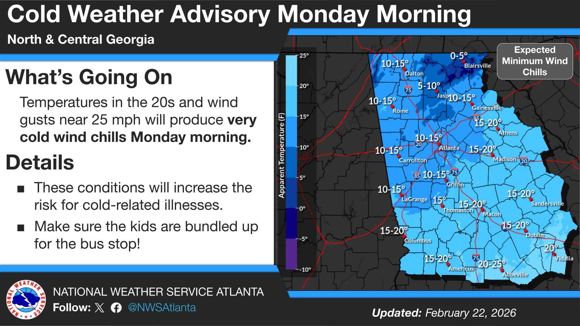
Sunny and calm weather will continue across north and central Georgia through Saturday, with temperatures quickly warming after a cool, frosty start Friday morning. High pressure will keep skies mostly clear while winds turn southerly, helping afternoon temperatures climb back into the 70s and even low 80s by Saturday — well above normal for mid-March.
Residents across Chattooga County and Northwest Georgia are facing a double dose of winter weather as a Wind Advisory remains in effect until 7 p.m. Sunday, followed by a Cold Weather Advisory from 1 a.m. to 10 a.m. Monday.
Breezy northwest winds and a sharp drop in temperatures are impacting Chattooga County and much of Northwest Georgia today, with colder air expected to linger through Monday.
The National Weather Service has issued a Wind Advisory from 8 a.m. to 7 p.m. EST Sunday as a tight pressure gradient between a developing Nor’easter and high pressure over the Plains drives strong northwest winds across Georgia.
A developing winter storm is expected to affect parts of the Southeast and Mid-Atlantic late Friday night into Saturday morning, bringing the potential for heavier snow and travel impacts mainly to areas east of Northwest Georgia. Forecast guidance continues to point the most significant winter weather toward the eastern Carolinas and into southern Virginia, with confidence increasing for impactful snowfall in those regions.
Georgia is on high alert as an impending winter storm approaches, and while much of North Georgia will see frozen precipitation over the next 48 hours, Northwest Georgia’s risk remains lower than areas to the east. Expect cloudy skies and periods of light rain today, a brief wintry mix potential Saturday morning before changing back to rain, the highest concern for freezing rain Saturday night into Sunday morning (especially on Lookout Mountain), and then the bigger story: bitterly cold Arctic air arriving to start next week.
Snow is expected to remain to the east and south of Chattooga County, while local residents see a colder, quieter stretch of weather through early next week. Cloudy skies will hang on through midmorning today before gradual clearing takes over, with temperatures topping out near 41 degrees. A west wind of 5 to 10 mph will add a bite at times, with gusts that could reach 20 mph.
Light Rain Returns Tonight for Chattooga County and Northwest Georgia, With a Low-Confidence Winter Storm Signal This Weekend
A fresh blast of arctic air is sliding into Northwest Georgia, and Thursday morning (Jan. 15) is shaping up to be the coldest stretch of the week for Chattooga County and surrounding communities. Forecasters say biting wind chills between 0° and 15°F are expected across north Georgia as breezy northwest winds follow a passing cold front, making it feel far colder than the thermometer suggests.


