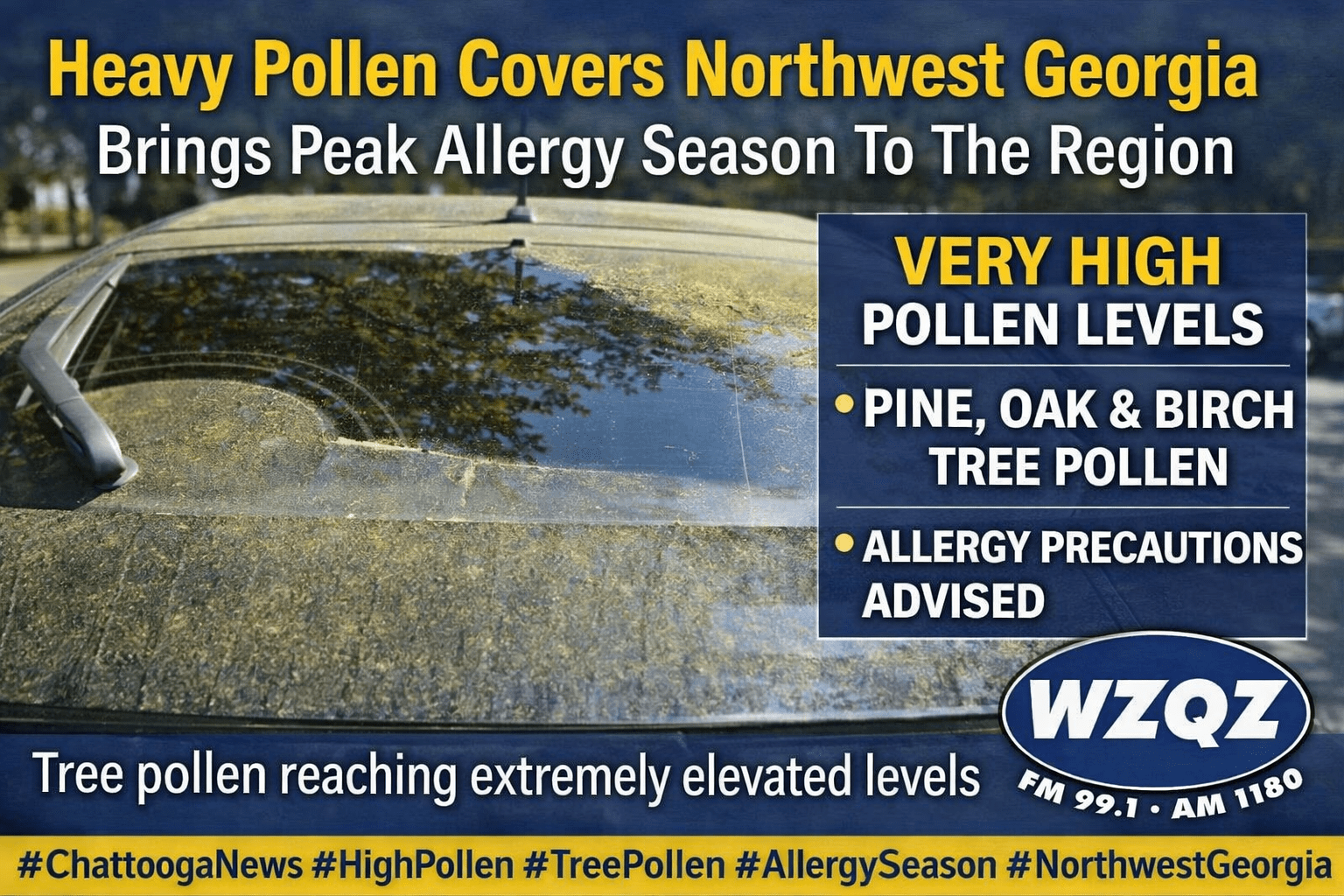
If your car looks yellow this week, you’re definitely not imagining it. Pollen levels across Chattooga County and Northwest Georgia are currently very high, with tree pollen reaching peak levels in late March and leaving a visible coating on cars, porches, patios, and outdoor furniture.
Residents across Chattooga County and Northwest Georgia can expect mild and dry conditions through midweek, but officials are warning of an increased fire danger Tuesday afternoon into the evening.
A weak wedge of cooler air is settling into the region, bringing partly cloudy skies, gusty northeast winds, and seasonable temperatures in the mid to upper 60s. Behind a recent cold front, much drier air has moved in, dropping humidity levels into the 20–30% range.
Forecasters say areas north of I-20, including Northwest Georgia, could see relative humidity fall below 25% for several hours Tuesday. Combined with dry vegetation and breezy conditions, this has prompted a high fire danger alert for the region.
Conditions remain calm and dry into Wednesday, with little to no chance of rain. However, a warming trend begins later in the week, with temperatures climbing into the upper 70s and low 80s by Thursday.
A weak cold front could bring a slight chance of scattered showers to far north Georgia by Friday, but overall, quiet and seasonable weather is expected heading into the weekend.
Officials urge residents to avoid outdoor burning during peak fire danger periods and to use caution with anything that could spark a fire.
Today
Mostly cloudy, then gradually becoming sunny, with a high near 69. Northeast wind 5 to 10 mph becoming southeast in the afternoon. Winds could gust as high as 20 mph.
Tonight
Partly cloudy, with a low around 46. East wind around 5 mph, with gusts as high as 15 mph.
Wednesday
Partly sunny, with a high near 68. Southeast wind around 5 mph, with gusts as high as 15 mph.
Wednesday Night
Partly cloudy, with a low around 50. Southeast wind around 5 mph becoming calm.
Thursday
Mostly sunny, with a high near 82. Calm wind becoming southwest around 5 mph in the afternoon. Winds could gust as high as 15 mph.
Residents across Chattooga County and Northwest Georgia can expect one more day of unusually warm weather today before a cold front pushes temperatures back down early this week.
Chattooga County and the rest of Northwest Georgia are heading into a stretch of unseasonably warm weather this weekend, with temperatures expected to run 15 to 20 degrees above normal through Saturday, Sunday, and Monday. Afternoon highs will climb into the low to mid 80s across the region, creating a much more summer-like pattern than what is typical for late March.
A noticeable warm-up is settling into Chattooga County and the rest of Northwest Georgia, with temperatures expected to climb a little higher each day through the weekend. After the recent stretch of chilly mornings and frosty conditions, temperatures are now turning sharply warmer, bringing a much more springlike pattern to the region.
Residents across Chattooga County and Northwest Georgia should prepare for another hard freeze tonight into Wednesday morning, as temperatures remain well below normal for mid-March.
Strong to severe thunderstorms weremoving through Chattooga County and Northwest Georgia early Monday morning, bringing the threat of damaging winds and a few brief tornadoesas a powerful squall line pushes across the region.
Severe storms possible overnight, hard freeze follows in Chattooga County and Northwest Georgia
A dangerous stretch of weather is setting up across Chattooga County and Northwest Georgia, beginning with isolated showers and thunderstorms this afternoon, followed by a more widespread severe weather threat after midnight, and then widespread freezing temperatures Monday night and again Tuesday night.
Sunny and calm weather will continue across north and central Georgia through Saturday, with temperatures quickly warming after a cool, frosty start Friday morning. High pressure will keep skies mostly clear while winds turn southerly, helping afternoon temperatures climb back into the 70s and even low 80s by Saturday — well above normal for mid-March.
A cold front that brought showers and thunderstorms across Chattooga County and Northwest Georgia early Thursday morning is expected to move out of the area by early afternoon, leaving gusty winds and cooler air behind.